

Lagos - Fulcrum (Orita-Meta) of Coastal West Africa Economic Corridor
The proposed road infrastructure to connect West Africa could help to eliminate colonial borders.

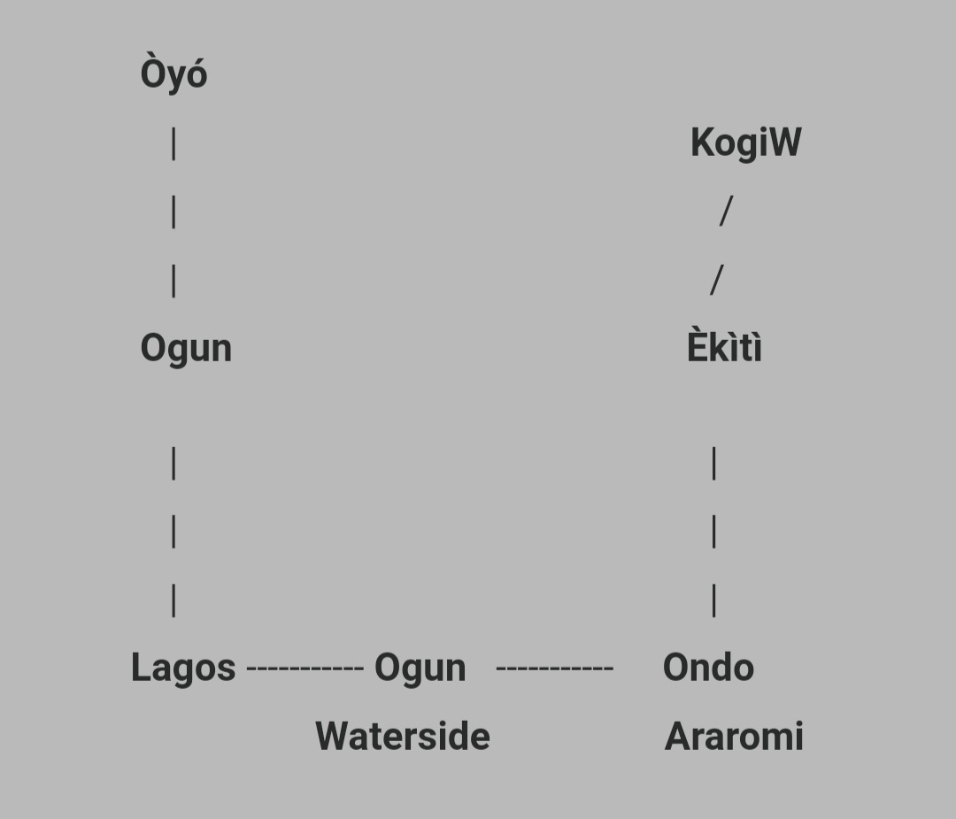
The Lagos Corridor, also known as "Greater LAGOS" for the purposes of this article, is located at the Orita-Meta (intersection) of the Lagos-Ogun-Oyo/Ondo Economic Corridor. This article focuses on three significant road infrastructure projects discussed below:
Abidjan - Lagos Corridor Highway
The $15.6 billion Abidjan-Lagos Corridor Highway, which would require approximately $6.8 billion in private sector finance, is expected to begin construction in 2026 and be completed by 2030. Its goal is to improve trade and promote regional integration in West Africa.
Spanning 1,028 kilometers, the transnational coastal road is scheduled to connect 🇨🇮 Côte d’Ivoire to 🇳🇬 Nigeria while traversing 🇬🇭 Ghana, 🇹🇬 Togo, and 🇧🇯 Benin (connecting Abidjan, Accra, Lomé, Cotonou, and Lagos).
It has 63 interchanges along its course and is intended to be a toll-free road with four to six lanes, with the potential to expand to eight lanes in Lagos.
The Federal Government, Lagos State Government, and the Federal Roads Maintenance Agency (FERMA) would share responsibility for constructing Nigeria's section of the projected Abidjan-Lagos Corridor Highway.
Lagos - Calabar Coastal Highway
Under development, the 750-kilometer Lagos-Calabar Coastal Highway would connect Victoria Island in Lagos with Calabar in Cross River State.
It aims to increase connectivity and commerce along Nigeria's coastal areas. The route is intended to travel through a number of states, including Ogun, Ondo, Delta, Bayelsa, Rivers, and Akwa Ibom. Along the highway, railway transit is anticipated to operate.
The Lagos-Calabar Coastal Highway is expected to be finished by 2031, with construction having started in March 2024.
President Bola Tinubu is anticipated to launch 30 km of the route by May 25, 2025.
Sokoto - Badagry (Lagos) Highway
Nigeria's Federal Government has officially begun building on the 1,068-kilometer Sokoto-Badagry Superhighway. The project, which begins at the town of Illela in the Illela Local Government Area in Sokoto State, is anticipated to traverse Sokoto, Kebbi, Niger, Kwara, Òyó, Ogun, and Lagos States.
The government will have to spend a total of 13 trillion naira on the Lagos-Calabar and Sokoto-Badagry projects, with 52% of the route in the north and 48% in the south. Railway transportation will operate beside the highway in this project as well.

Economic Corridor of this Orita-Meta and Nexus to Yorùbá Civilization
In Yorùbá Orisa Pantheon, Orisa Esu Laalu (Esu Ola Ilu - Esu Wealth of a Nation) is typically associated with Orita-Meta (crossroad/intersection) and markets (trade and commerce). Orita-Meta is the crossroad/fulcrum of three pathways, with Lagos serving as this critical node where Abidjan (Coastal), Calabar (Coastal), and Illela/Sokoto (Sahel) meet to exploit economic/commercial/trade opportunities concentrated in these corridors.
Another significant Orisa/Imole is Olokun, which is typically associated with the ocean/sea, wealth, salt, and glass beads (representing trade). The Abidjan-Lagos-Calabar Coastal Highway connects West Africa's commerce, trade, and wealth by passing along the coastal corridor and the sea or ocean.
Greater LAGOS Corridor: The Yorùbá Economic Corridor within Nigeria
The term "Greater LAGOS" refers to a single economic corridor that runs across the hinterland from Lagos to Ogun State and Òyó State, and along the coast from Lagos to Ogun State (Waterside) and Ondo State. The most significant economic corridor in Nigeria is the country's manufacturing capital, accounting for around 89% of all Nigerian manufacturing output and primarily being a non-oil economy.
However, it's emerging as a major oil economy in West Africa with the Dangote Refinery located in this corridor, a proposed Olokola Deep Sea Port (already pledged by Dangote), a proposed Ondo Deep Sea Port, a bitumen refinery, and perhaps a superhighway/rail connecting coastal Ondo to hinterland Èkìtì/Kogi West, therefore creating another new economic corridor: “Lagos-Ondo-Èkìtì”
Trade, Commerce, and GDP
Within Nigeria, the South-West and South-South geopolitical zones as well as the hinterland South-East geopolitical zone, will be connected by the Lagos-Calabar Coastal Highway and Railway, linking areas with significant economic activity. Connecting five nations in Littoral West Africa, the Abidjan-Lagos Transnational Coastal Highway will pass through their major coastal cities and even their capitals. For simplicity, the entire coastal route from Abidjan to Calabar, encompassing the Abidjan-Lagos Transnational Coastal Highway and the Lagos-Calabar Coastal Highway, will be referred to as the "Abidjan-Calabar Coastal Corridor."
Maritime and Blue Economy
The coastal highway between Abidjan and Calabar will run through all of the port cities starting from Côte d'Ivoire and ending in coastal Calabar. It may also connect the ports and the valuable seafood and fish-based economy in this corridor.
Energy, Gas, Oil, and Power
It is planned to construct wind farms along this coastal corridor in order to provide electricity for the developing coastal cities, trade, and commerce. This corridor is expected to see the emergence of crude oil refineries, bitumen refineries, and gas facilities for production, supporting industrialization. Examples include the Dangote refinery.
Housing, Tourism, and Hospitality
New cities with proper urban planning and amenities for the twenty-first century will emerge along this corridor; Eko Atlantic City in Lagos State is one example. Opportunities for the housing, tourism, and hospitality sectors, driven by private investors, include bars, restaurants, large and exotic hotels, housing estates, resort centers, recreational and sports centers, etc.
Transnational Trade - Erasing the 1884 Berlin Borders
The Abidjan-Calabar coastal corridor will emerge as an integrated economic corridor without borders, without barriers, such that a building complex may theoretically occupy two countries at their borderline. Some Free Trade Zones (FTZs) have already emerged in this corridor, e.g., Lekki FTZ (Lagos), Olokola FTZ (Ogun and Ondo), Koko FTZ (Delta) state, GDIZ (Benin Republic), etc. However, new ones are expected to emerge along this corridor.
Beyond the Berlin Border - Restoring Africa's Nations and Civilisations

A nation is born from commonalities of groups that exist within its bounds. Observing the different nations of the world across different continents, a pattern emerges, especially in terms of the economic success and stability of such nations. A common pattern among these nations is the homogeneity of their societies. Although a Mono-Ethnic country is a rare find however, the stability of nations can be observed to correlate to how homogenous they are.
Demography and Population
In Yorùbáland, most of the major and highly populated cities, including Akure, Ibadan, Abeokuta, Ilorin, Ogbomoso, Ifè, Ado Èkìtì, and Ondo, are located in the hinterland, far away from the coast, with the exception of Lagos.
With a population of roughly 25 million, Lagos is the only exception to this trend. It has one of the largest economies in Africa and the most viable economy of any Nigerian state or region. However, there could be a massive increase in the population of this corridor due to "population transfer" from coastal cities and hinterlands, such as Ode Omi, Ode Makun Omi, Igbogun, Ibeju Lekki, Araromi, Ilaje/Igbokoda, Koko/Ogheye, etc.
About 60% of West Africans are projected to live in this coastal corridor by 2050, with Nigeria leading the way and the South-West region being the primary home to the majority of this growth. Trade and commercial activities, as well as the viability and industrialization of this corridor, will be strongly impacted by this population boom.
In addition, the Sokoto-Badagry (Lagos) Highway/Corridor will cause a population shift due to the presence of major agribusiness and logistics companies facilitating trade and commerce between coastal West Africa and the Sahel via the Niger Republic. Illela in Sokoto is the border between Nigeria and the Niger Republic.

Depopulation of Lagos State into the Extended Coastal Economic Corridor
Lagos State is Nigeria's smallest state by landmass; nevertheless, it's Nigeria's largest state by population. Lagos has more people per square kilometer than any other place in Nigeria or even West Africa. As a result, the public infrastructure is overburdened, housing shortages are severe, sanitation and waste management issues are challenging, crime rates are rising, air and noise pollution is a problem, and traffic congestion is a problem.
But thanks to the Abidjan-Calabar Coastal Highway and Corridor, Lagos workers may live and work in Ondo, Ogun, the Benin Republic, and other places with ease and short commutes. With the railway median within the highway, freight trains can transport large cargo without having to utilise large trucks on the highway, thereby preventing accidents and reducing pressure on the roadway. The cost of living and housing may be lower for someone who lives in Ogun or Ondo State and works in Lagos.
Transportation Service
The South-West geopolitical zone, through the DAWN Commission and the newly formed South-West Development Commission (SWDC) are advised to further their investment in modern infastructure to ease the burden which is expected to rise exponentially.
This also offers a huge possibility to create economic opportunity for thousands of citizens along the network of corridors connecting Abidjan, Lagos, Calabar, and Sokoto as well as beyond it.
Side note: The Sokoto (Illela)-Lagos (Badagry) and Abidjan-Calabar Corridors are both significant economic corridors, although I believe the former is more significant.

The cross ➕ roads of economic prosperity is Yorùbá land
I'd also like to brainstorm with you on how to leverage yhe Bantu speakers in the Middle belt region to create a sociocultural and economic corridor 🚃 to parts of East Africa 🌍
Nice article